Kezar Lake
Kezar Lake (Midas #0097) is a non-colored waterbody located in the Town of Lovell, Oxford County, Maine. The lake stretches 9 miles from north to south, covering 2,665 acres (4.16 square miles) and has a maximum depth of 160 feet (49 meters) and a mean depth of 34 feet (10 meters). Water quality monitoring data have been collected since 1970 at Station 1 (upper), 1976 at Station 2 (middle), and 1976 at Station 3 (lower).
Water Quality

water Clarity
Since the early 1970’s, water clarity at all three basins of Kezar Lake has improved with the upper and middle basins improving by nearly 1 meter. The slight, but statistically significant, improvement at the lower basin is an artifact of changing lake depth since nearly all readings hit bottom.

total phosphorus
Since the late 1970’s, total phosphorus at all three basins of Kezar Lake has revealed no statistically significant trend over time. The generally higher median annual total phosphorus observed at the lower basin is an artifact of its shallow depth, where wave action can disturb bottom sediments that release phosphorus into the water column.

chlorophyll-a
Since the late 1970’s, chlorophyll-a at the upper basin of Kezar Lake has improved, while chlorophyll-a at the middle and lower basins has revealed no statistically significant trend over time. The period from 1994 to 1999 saw a marked rise in chlorophyll-a at the upper basin, but chlorophyll-a has remained at or below 3 ppb since then. Nutrient-rich runoff entering the lake during wetter years, combined with warmer air temperatures, can fuel algal growth.
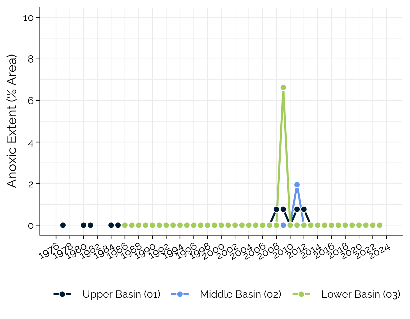
anoxic extent
Dissolved oxygen profiles show good oxygenation throughout the water column over the collection period. The extent and duration of anoxia is excellent at all three basins.

temperature
The volume-weighted average surface water temperature for the top 2 meters showed a statistically significant increasing (degrading) trend of about 0.5-1 °C at both the upper and lower basin of Kezar Lake. This is likely a signal of climate change; correlations with air temperature and precipitation may help tease out the relative contribution of weather variables on lake surface temperature.

ph
Since the early 1980’s, pH at all three basins of Kezar Lake has revealed no statistically significant trend over time. Generally, pH becomes more acidic as total alkalinity in the epilimnion declines. Low alkalinity makes Kezar Lake susceptible to changes in pH, particularly from acidic deposition in the form of rain or snow, which can jeopardize the health of freshwater fish species.

total alkalinity
Since the early 1980’s, total alkalinity at the upper and lower basins of Kezar Lake has degraded by nearly 3 ppm, while total alkalinity at the middle basin has improved by 2 ppm. The region has naturally-low alkalinity (or buffering capacity) as a result of its contributing geology (i.e., granite) that lacks carbonates, bicarbonates, and carbonic acid.

color
Since the early 1980’s, color at Kezar Lake has revealed no statistically significant trend over time. Color is highly related to summer precipitation; wetter years show higher color as more materials are washed off the landscape to the lake. The lack of trend in color is despite the increase in regional precipitation observed in the last century, suggesting that more data are needed to confirm the trend. However, 2023 showed record highs for color in the upper and middle basins, likely due to the high levels of precipitation throughout the summer.
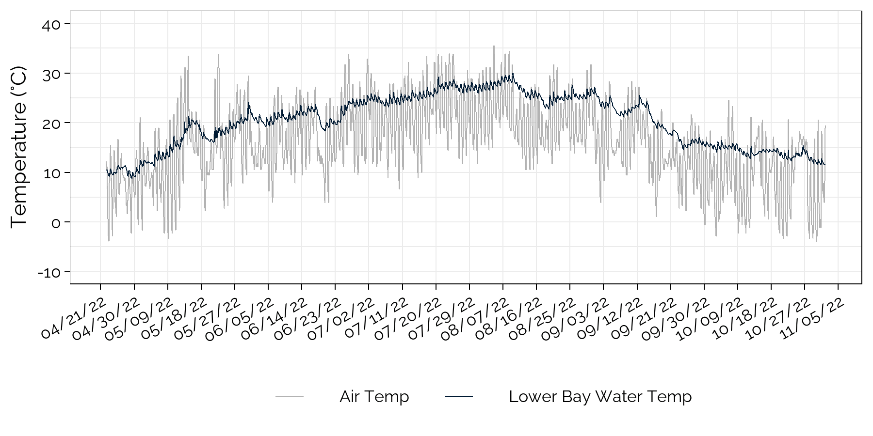
Lower Bay nearshore water temperature
Water temperature followed closely with air temperature (hourly data obtained from Fryeburg weather station).

lower bay nearshore historical water temperature
Median annual water temperature (denoted by solid line in grey box) is difficult to compare across years because of deployment position changes at the lower bay site (consistent nearshore site from 2017-present). Winter ice along the shoreline caused significant damage to the deployment structure in 2015-16.

lower bay relative surface water height
Water level data collected at the lower bay showed that lake level gradually responded to a series of storm events throughout the deployment period but otherwise remained consistent throughout the season.