Sediment Core Sampling
One of the most effective ways to understand the long-term effects of climate change on lake ecosystems is to compare past conditions with current ones. Since sediments that accumulate at the bottom of a waterbody are the result of the biological, geological, and climatological changes within each waterbody’s watershed, they provide a sequential record of past conditions in lake productivity, stratification, oxygenation, and material inflows from streams and watershed runoff.
The KLWA CCO has been collecting and analyzing sediment cores from Kezar Lake and Horseshoe Pond over the last five years. Our purpose is to better understand observed watershed trends by determining environmental conditions in the watershed over the past 200 to 1,000 years. When sediment cores were taken from Kezar Lake in 2015, a key finding was an unexpected exponential rise in sediment accumulation rate since 1980. In an attempt to solve this mystery, the CCO decided to take cores from Horseshoe Pond in 2019 for comparison.
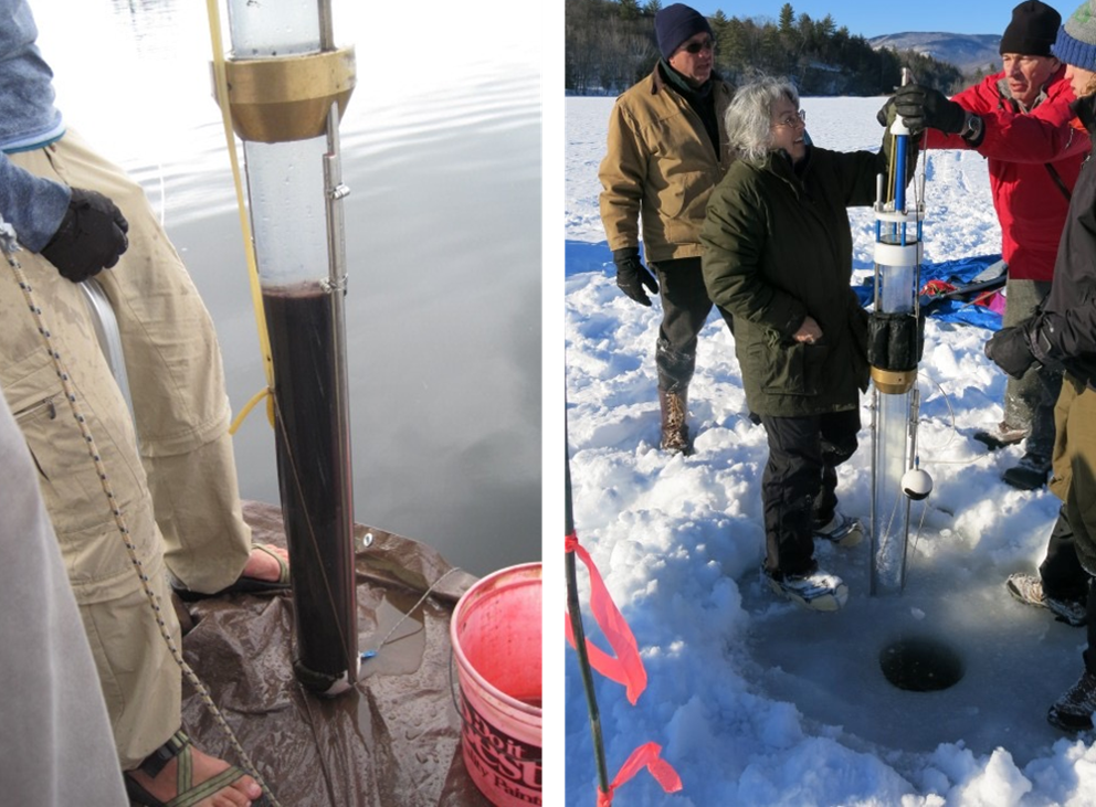
Sediment core collection from Kezar Lake in June 2015 (left) and February 2015 (right). Photo credit: KWLA.
Kezar Lake
The CCO’s sediment core study of Kezar Lake aimed to better link water quality with climate and land use and to determine which stressors have put Kezar Lake water quality at greatest risk of future impairment.
Sediment cores were collected in February 2015 through the ice from the deepest location in two basins - at the northern end of the lake near the Great Brook outlet and the 155-ft deep spot in the upper bay. Additional cores were taken in July 2015 at these same two locations. These cores have been selectively analyzed and dated.
Summary
Natural processes affecting water quality within the Kezar Lake watershed were relatively stable until the Europeans arrived in the 1800’s.
The Europeans logged forests, plowed fields, raised farm animals, trapped beavers, and built roads, resulting in significant changes to the landscape.
The Industrial Age added other stressors and pollutants, such as acid rain, heavy metals from the burning of fossil fuels, chemicals from fertilizers and other uses, and high-powered boats that create wakes and disturb bottom sediments.
The synergistic effect of human activities and rising temperatures due to climate change is having a measurable impact on our environment.
Major Study Findings
Between A.D. 2000-2015, the sediment accumulation rate and organic content of both the deep spot of Kezar Lake and the area near Great Brook increased dramatically, possibly due to increased erosion induced by climate change effects of more frequent and violent storms (although these effects have not been recorded in our watershed) or by some other mechanism, such as boat wakes.

Sediment accumulation rate (cm/year) from A.D. 1892-2015 (lead-210 dated) for the Kezar Lake Deep 2015 Core 3. Figure adapted from L. Doner, PSU.
Preliminary diatom results indicate that a marked change in algal composition accompanied the increase in sediment accumulation rates after 2008. This supports the idea that the lake is not currently as stable as it was just a decade ago.
The particle-size record at the deep spot of Kezar Lake suggests that no large-scale events have occurred in the Kezar Lake watershed since the large hurricanes in the 1600’s, despite forest clearances in the 1800’s and fires in the 1930’s. The Great Brook core record showed the influence of many smaller-scale events that are most likely associated with minor flood events.
The deep spot of Kezar Lake showed a steady rise in lead and zinc from the burning of coal and gasoline since the 1800’s, then a sharp decline in the 1970’s after the ban of leaded gas. The Great Brook core record did not show as sharp a decline in lead and zinc as at the deep spot, which may indicate a continued source of heavy metal contamination from dredged or disturbed lake sediments with legacy contamination.
The full analysis for the 2015 Kezar Lake sediment cores can be found in the 2016 CCO Annual Report.
Horseshoe pond
Purpose & Methods
Concerned with the marked increase in sediment accumulation rate (from increase in erosion rate) in Kezar Lake, the CCO collected a sediment core in Horseshoe Pond (minimally impacted from human activity such as boat wakes) to compare to the Kezar Lake core as a way to determine whether increased sediment accumulation rate is likely due to direct human impact or climate change effects.
A team of KLWA/CCO volunteers collected sediment cores from Horseshoe Pond in July 2019 and February 2020 in collaboration with Plymouth State University (PSU). Supervised by Dr. Lisa Doner, PSU is doing a scientifically robust paleolimnology study of the Horseshoe Pond core and comparing results to their analyses of Kezar Lake’s core samples. Noting differences between the two bodies of water may help us to better understand the increasing sediment accumulation rate and whether we can mitigate any future increase. Dr. Steve Arcone, an Adjunct Professor at Dartmouth College and the University of Maine Climate Change Institute, also completed a ground penetrating radar (GPR) profile of the pond while the coring was being done in February 2020.
To create a profile of the sedimentary architecture of the pond bottom, GPR equipment was deployed and pulled across the ice in several cross-pond transects as shown on the map below. GPR equipment emit short pulses of radio waves to quantify changes in reflections caused by interfaces between sediments with various water content. Results of the sediment core related to density and water content of the sediments can be used to essentially “calibrate” the GPR images to the appropriate penetrating depth.
![Map of transects obtained for GPR [LEFT]. GPR in action on Horseshoe Pond [TOP RIGHT]. PSU and local volunteers preparing for the coring [MIDDLE RIGHT]. PSU collecting an 88 cm core from Horseshoe Pond in the first attempt[BOTTOM LEFT]. PSU pushing …](https://images.squarespace-cdn.com/content/v1/5d52deee2cb2ef000172e36d/1588851822620-XL3NSVC6I17VS3SYQY7U/horseshoe_gpr.png)
Map of transects obtained for GPR [LEFT]. GPR in action on Horseshoe Pond [TOP RIGHT]. PSU and local volunteers preparing for the coring [MIDDLE RIGHT]. PSU collecting an 88 cm core from Horseshoe Pond in the first attempt[BOTTOM LEFT]. PSU pushing the pipe assembly into the sediment for the second core [BOTTOM RIGHT]. Photo credit: KLWA. Map courtesy of Dr. Arcone.
Preliminary Results of the GPR
As an example, a GPR profile is shown below. Preliminary analysis shows that the GPR penetrated the ice, the water, and several layers of bottom materials up to about 20 feet deep. It appears that Horseshoe Pond was formed by glacial gouging some 22,000 years ago. The pond looks like an ancient Fjord gouged out of bedrock, and the GPR suggests an even narrower channel. As the glacier retreated to the area of Horseshoe Pond about 14,600 years ago, it deposited boulders, rocks, and other debris called till that is estimated to be about 5 meters thick. On top if this till, various erosion processes driven by storms and hurricanes, as well as atmospheric depositions and earthquakes, have layered about 7 meters of sediment on the bottom called gyttja. With 12 meters of water, 7 meters of organic sediment (gyttja), and 5 meters of till, the bedrock in Horseshoe Pond is estimated to be at least 24 meters deep or about 80 feet, nearly twice the current depth of the water.
Refer to Dr. Arcone’s report for more information on the GPR techniques and analysis.
The synergy of the analysis of the core data, along with the GPR data, provides an enhanced understanding of the environmental history of Horseshoe Pond, which will assist in solving the mystery in Kezar Lake.
Refer to the CCO article “The Mystery of Sediment Accumulation Rate in Kezar Lake” for more information on the Horseshoe Pond project.
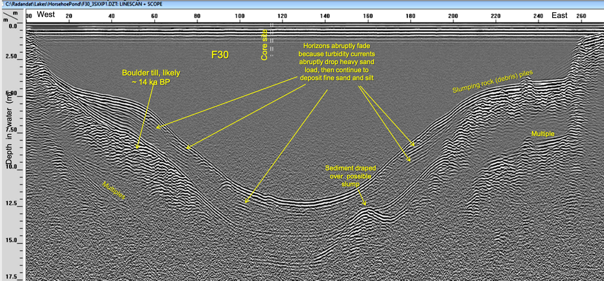
GPR profile for Transect F30, which runs east to west by the deep spot where the core was collected. Courtesy of Dr. Arcone.
Future Core Studies
For the Kezar Lake cores, we expect to complete the diatom analysis and integrate those results with the existing data sets (funding permitting). Diatom (microscopic algae) assemblages provide information on how aquatic plant species changed over time. Depending on the aquatic species that changed, it is possible to estimate historic air and water temperature, as well as historic water quality conditions, like pH, alkalinity, clarity, and nutrient availability.
We also plan to obtain a lead-210 (210Pb) dating of one of the Great Brook cores to more accurately correlate the data sets from the Kezar Lake deep spot and the Great Brook cores (funding permitting). Radiocarbon dating of a subsample (around A.D. 1600) of the Kezar deep spot core would also be helpful in validating the timeline for the rate of sediment accumulation.
The Horseshoe Pond coring is still being dated and analyzed and the results, along with added GPR data, should be available in late 2020. By calibrating the sub-bottom radar signal velocity, Dr. Arcone will be able to determine the occurrence of sandy layers and their stratification, as well as verify his interpretation of turbidities and dates.